Wednesday, 31 July 2013

Day 55: Truro to Porthleven

Distance: 21.2 miles
Time: 7 hrs 55 mins
Weather: Light drizzle
Cumulative distance: 928.3 miles

A day of country lanes and footpaths in the drizzle, a few missing signposts, the seaside and a family reunion.

After breakfast, we set off in drizzle and soon reached a country lane which took us away from civilised Truro towards Bissoe, but which was also a short cut popular with local motorists.

We stopped for an early lunch at Stithians - our first Cornish pasty, which we ate whilst sat on a bench in the rain. It still tasted good, even if we departed somewhat damper.

We followed a couple of footpaths which resulted in shorter routes, but came unstuck on a later footpath due a lack of signposts. We found ourselves next to a reservoir, having deviated from the scheduled route, but quickly found an alternative route. Unfortunately, another missing signpost resulted in a further deviation and we were soon walking across a field in the mist, not quite sure how to rejoin our route. With the assistance of GPS, we were back on track, but time and miles had been expended unnecessarily.

At Porkellis, we stopped for a coke at an inn. As we left, the landlord came running after us to tell us we were heading in the wrong direction for Land's End, so I had to explain that we would be walking along the scenic coastal path to get there.

After a longer than planned walk, which Daniel's legs did not appreciate, we skirted Helston, climbed over the hill and finally arrived at the bustling harbour of Porthleven, to be reunited with my wife and daughter for the first time in two months.

Our hotel was nearby, offering super views across the harbour (see photo). This was the first time I'd been so close to the sea since the early days of the walk in Scotland. It was good to smell the brine and to hear the sound of the gulls flying overhead.

We had a family meal at the Blue Haze fish restaurant on the opposite side of the harbour. The meal was excellent and there were splendid views over the harbour. My drink? A bottle of Porthleven ale from Skinner's brewery - what else?

Tuesday, 30 July 2013

Day 54: Roche to Truro

Distance: 18.7 miles
Time: 6 hrs 30 mins
Weather: Morning drizzle, dry and bright later
Cumulative distance: 906.1 miles

Cornish country lanes in the rain, danger on the A39, quiet tracks, 900 miles clocked and delightful accommodation in Truro.

We each consumed the contents of our Travelodge breakfast box (orange juice, cornflakes and milk, croissant and muffin), then set off in light drizzle to the centre of Roche, where we purchased lunch from the Co-op.

We passed through Nanpean and St Stephen, before stopping at Ladock, where we sat on a bench next to the portacabin shop and post office to have lunch. Soon afterwards the rain stopped and the sun gradually saw off the clouds.

After St Erme we had to join the main A39 for about a mile. Despite being a busy, major road, there were no cycle or pedestrian paths and the grass verges were either too narrow or non existent. This only confirmed my observation that Cornwall's major roads are the least pedestrian and cycle friendly of all the roads I have experienced in the last two months.

It was a relief to join a minor country lane which followed a wooded valley and eventually led us to the outskirts of the fine city of Truro. Inevitably, our B&B was located at the top of a hill just outside the town centre.

The Townhouse provided a friendly welcome,a very comfortable room and a hot shower, but additionally it offered complimentary hot drinks and home made cakes.

In bright sunshine, we wandered down the hill to explore the centre of Truro. The shops were closed, but we did spot the Christmas shop (only 147 days to go!) and the impressive cathedral, which dominates the skyline. We dined at Pizza Express, housed in the former Coinage House.

I reached the 900 mile landmark today, but the days and the miles are running out. I feel that I need to savour every remaining moment, as my epic journey nears its conclusion.

Monday, 29 July 2013

Day 53: Mount to Roche

Distance: 13.6 miles
Time: 4 hrs 5 mins
Weather: Cloudy, showers, sunny later
Cumulative distance: 887.4 miles

A leisurely morning stroll, a station reunion and a walk to an industrial estate with rural views.

I ate breakfast with Wayne and family, then they set off for home. The B&B owner kindly allowed me to stay beyond the normal departure time as, for once, I was in no hurry to leave. It wasn't the heavy showers which deterred me, but the fact that I only had 6 miles to walk before meeting my son Daniel at Bodmin Parkway station.

I followed a quiet country lane down towards the A38, when I was suddenly caught by a heavy shower for the second day in a row. I had to walk along the A38 for about 1.5 miles to the station junction, but it soon became the most difficult road of the entire journey. There was no pedestrian path and heavy goods vehicles thundered by at speed, so my only option was to jog along the roadside when there were breaks in the traffic. Crossing over to the station road proved to be another challenge as the junction was positioned next to two bends in the road. Eventually, I arrived safely at the station, which was a floral delight, with colourful displays along each platform. I ate lunch and watched the steam hauled passenger train of the Bodmin and Wenford railway arrive at the opposite platform.

Daniel's train pulled in impressively on time and I greeted him for the first time in nearly 8 weeks. He'd come to join me for the final 5 days of the walk, but I silently hoped that he'd done sufficient training while I'd been away.

We walked at pace, taking a short cut through the Lanhydrock estate, then followed a country lane which ran parallel to the busy A30 highway, until we finally reached an industrial estate, where our Travelodge accommodation was located. Despite its industrial base, our room offered rural views, including the local donkey sanctuary. We dined next door at the Victoria Inn (a wide choice of food and efficient service).

Sunday, 28 July 2013

Day 52: Launceston to Mount

Distance: 19.3 miles
Time: 8 hrs 15 mins
Weather: Rain showers
Cumulative distance: 873.8 miles

Wet weather, waterproofs, Wayne, and warm welcomes.

After another fine breakfast, I checked out and climbed the hill up to the town centre. There I met Wayne, a former work colleague, an Aussie who was born in Launceston, Tasmania. He is a cricket fanatic, having formerly partnered Test player David Boon, and still plays occasional first team cricket for Egham. Wayne had chosen potentially the wettest day to walk with me, while the rest of his family visited the Eden Project.

For the first time since Beattock in Scotland (day 21) I wore my waterproofs - that's a whole month ago! We immediately sheltered from the first shower under a shop canopy, then headed towards the quiet country lanes around Bodmin Moor. Our second shelter was a conveniently located church in a secluded village - this was despite the fact that the Sunday service that was in progress!

At Rilla Mill, we stopped for a coke at the village pub, but the enticing smell of the Sunday roasts nearly stalled us for longer. We journeyed on until Minions, where another pub lured us towards another coke, but this was more lucrative. The pub was brimming with diners and drinkers, locals and tourists alike, but they were most welcoming and gave generously at the sight of my collecting tin.

One particularly heavy downpour provided a soaking, but we dried off quickly in the subsequent breeze. We finally reached St Neot, national village of the year in 2004, where Wayne's feet decided it was time to call his chauffeur. I continued a few miles to Mount, where tonight's B&B was located. After a rapid shower, I joined up with Wayne and his family (wife Nicky and daughters Lauren and Cassie) and we drove to the London Inn at St Neot. I opted for the sea bream, served with cherry tomatoes and olives and sampled the local multi award winning brew, Betty Stogs from Skinners of Truro.

Saturday, 27 July 2013

Day 51: Lewdown to Launceston

Distance: 10.8 miles
Time: 3 hrs 30 mins
Weather: Cloudy with sunny intervals
Cumulative distance: 854.5 miles

Last night, Sylvia cooked a delicious dinner of pork in cider sauce, with a selection of vegetables (including Swiss chard, courgettes and peppers fresh from the garden). Afterwards, the two children Charlie (11) and Chloe (10), who are both very artistic, entertained me with tales of life on a farm - Chloe had already taken me up into the field to be introduced to her pet lambs, every one of which had a name! The other guests, who were also family friends, then arrived, Sylvia's husband Robert joined us and we all chatted until nearly midnight.

I had a fine farmhouse breakfast, then Ian phoned me at the farm to let me know that he wouldn't be able to join me today. Unfortunately, he had the trail guide, so I would have to navigate with the map alone. I checked out and set off across farmland and woods. The route was well marked on the map, so I need not have worried.

After a few hours, I left Devon and entered Cornwall, the final county of my journey. Land's End beckons, but the weather forecast is not encouraging.

I arrived in Launceston early, so sat on a bench in the main square and ate my lunch. I wandered around the centre and viewed the castle, but lasting impressions were of a very hilly town. Unfortunately, my B&B was near the bottom of a hill, which will mean a long and steep climb in the morning.

After a shower and a snooze, I walked a short distance down the road and dined at the White Horse Inn.

Friday, 26 July 2013

Day 50: Okehampton to Lewdown

Distance: 14.6 miles
Time: 5 hrs 50 mins
Weather: Warm and sunny
Cumulative distance: 843.7 miles

A pleasant accompanied walk along the Two Castles Trail and an accommodation hiccup.

After a delicious breakfast with extensive choices and equally extensive conversation with my host Ali, I walked down to the Tourist Information Centre to meet my two walking partners for the day. Ian, my brother in law arrived first, shortly followed by Lucie, my key contact at Cancer Research UK.

Ian lives in Plymouth and had travelled by car and bus to join me for the day and would do the same tomorrow. Lucie lives in London, but was visiting her parents in North Somerset for the weekend. She was accompanied by Diddie, her very well behaved terrier (named after Didier Drogba!).

In perfect walking conditions, we followed the trail across rolling countryside and woodland until we reached Bridestowe, where we visited the local pub for refreshments. Later on the signposts went into hiding and we strayed slightly from the route, rejoining it after crossing several fields. As with many of the official trails, we didn't pass a soul for the entire day.

We reached Lewtrenchard, where Ian had parked his car, and where Lucie and Diddie left us to retrace their steps back to Okehampton. Ian and I drove a few miles to have a welcome beer (Timothy Taylor's Landlord), then he dropped me off at my farmhouse B&B.

I could tell immediately from the look on Sylvia the owner's face that there was a problem. She'd not entered my confirmation into the book and was double booked - she was embarrassed and hugely apologetic. However, in true British spirit, within five minutes she'd produced a Devon cream tea for me and was relocating her daughter so that I had a room for the night!

Thursday, 25 July 2013

Day 49: Black Dog to Okehampton

Distance: 18.7 miles
Time: 5 hrs 55 mins
Weather: Cloudy and warm, sunny intervals
Cumulative distance: 829.1 miles

A pleasant rural walk through Devon villages, successfully managing to avoid the rain.

After a hearty breakfast, I said farewell to my welcoming hosts (who kindly made a donation) and set off down the road. I soon joined the Two Moors Way, another long distance path, which links Dartmoor and Exmoor. The path took me across farmland and through wooded glades. At one point a herd of around thirty cows followed me across a field, so it was quite a relief to reach the kissing gate into the next field. The path passed through the sleepy village of Morchard Bishop, where a senior resident told me that rain was imminent.

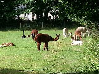
Just outside Morchard Bishop, the path weaved its way through an alpaca farm. I'd never seen these animals at close quarters before, but they seemed oblivious to my presence.

I left the Two Moors and joined a series of minor roads which passed through some pretty Devon villages - Down St Mary, Zeal Monachorum and North Tawton - with thatched cottages and impressive floral displays.

The weather forecast had indicated scattered heavy rain showers and my Rain Alarm smartphone app (which brother in law Chris had alerted me to) showed that I was surrounded by rain clouds, but amazingly I managed to avoid them and postponed donning my waterproofs for at least another day.

I arrived early in Okehampton, so ate my packed lunch in the sun and visited the Tourist Information Centre. As I arrived at my B&B, dark clouds gathered and a few raindrops began to fall. Ali, the friendly owner, told me that a few other LEJOG  walkers had stayed here  in the last year and she had printed off their blogs. I read one with amazement - one guy had walked the route in 2012 in 40 days without any rest days and most of his journey was undertaken in the rain. Impressive.

I walked down the hill and opted to eat at Vines Pizzeria, which Ali had suggested. A pepperoni pizza and two Peronis later, I ventured back up the hill.